3.2. Editing Features and Their Attributes
We will now enhance our application by making the layer and its attributes editable, and using WFS-T to commit changes.
3.2.1. Making Layer and Grid Editable
Let’s modify our application to allow for editing feature geometries and attributes. On the layer side this requires replacing the SelectFeature control that the FeatureSelectionModel automatically creates with a ModifyFeature control, and adding a DrawFeature control for creating new features. On the grid side, we have to replace the GridPanel with an EditorGridPanel, provide editors for the columns, and avoid multiple feature selection in the selection model (only one feature can be edited at a time).
Tasks
Open
map.htmlin your text editor. Create controls for modifying and drawing features, by appending the following to the application’s script block:var modifyControl = new OpenLayers.Control.ModifyFeature( vectorLayer, {autoActivate: true} ); var drawControl = new OpenLayers.Control.DrawFeature( vectorLayer, OpenLayers.Handler.Polygon, {handlerOptions: {multi: true}} ); controls.push(modifyControl, drawControl);
Append code to bind the FeatureSelectionModel to the SelectFeature control that is auto-created with the ModifyFeature control, and to make sure that only one grid row is selected at a time:
Ext.onReady(function() {
    var sm = app.featureGrid.getSelectionModel();
    sm.unbind();
    sm.bind(modifyControl.selectControl);
    sm.on("beforerowselect", function() { sm.clearSelections(); });
});
Append code to add Create and Delete buttons to the feature grid’s toolbar:
Ext.onReady(function() {
    var bbar = app.featureGrid.getBottomToolbar();
    bbar.add([{
        text: "Delete",
        handler: function() {
            app.featureGrid.getSelectionModel().each(function(rec) {
                var feature = rec.getFeature();
                modifyControl.unselectFeature(feature);
                vectorLayer.removeFeatures([feature]);
            });
        }
    }, new GeoExt.Action({
        control: drawControl,
        text: "Create",
        enableToggle: true
    })]);
    bbar.doLayout();
});
Find the featureGrid definition and change its xtype from “grid” to “editorgrid”:
xtype: "editorgrid",
ref: "featureGrid",
Find the columns definition for the featureGrid, and add appropriate editors. The final columns definition should look like this:
columns: [
    {header: "owner", dataIndex: "owner", editor: {xtype: "textfield"}},
    {header: "agency", dataIndex: "agency", editor: {xtype: "textfield"}},
    {header: "name", dataIndex: "name", editor: {xtype: "textfield"}},
    {header: "usage", dataIndex: "usage", editor: {xtype: "textfield"}},
    {header: "parktype", dataIndex: "parktype", editor: {xtype: "textfield"}},
    {xtype: "numbercolumn", header: "number_fac", dataIndex: "number_fac",
        editor: {xtype: "numberfield"}},
    {xtype: "numbercolumn", header: "area", dataIndex: "area",
        editor: {xtype: "numberfield"}},
    {xtype: "numbercolumn", header: "len", dataIndex: "len",
        editor: {xtype: "numberfield"}}
],
After saving your changes, point your browser to http://localhost:8080/ol_workshop/map.html. You should see the new Delete and Create buttons, and when you select a feature you can modify its vertices.
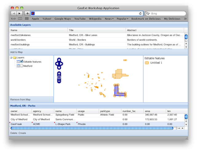
A synchronized map and grid view of WFS features.
3.2.1.1. The Changes Explained
For editing existing and creating new features, we use OpenLayers.Control.ModifyFeature and OpenLayers.Control.DrawFeature.
Both controls are configured with our vectorLayer. The DrawFeature control
needs to know which sketch handler to use for editing. Since our editing layer
is a polygon layer, we use OpenLayers.Handler.Polygon
here, and configure it to create MultiPolygon geometries (as required by
GeoServer) by setting the multi option to true:
var modifyControl = new OpenLayers.Control.ModifyFeature(
    vectorLayer, {autoActivate: true}
);
var drawControl = new OpenLayers.Control.DrawFeature(
    vectorLayer,
    OpenLayers.Handler.Polygon,
    {handlerOptions: {multi: true}}
);
The FeatureSelectionModel, if just used for viewing, is sufficiently
configured with its built-in OpenLayers.Control.SelectFeature.
For editing, we need to bind it to the SelectFeature control that is
auto-created by the ModifyFeature control instead:
var sm = app.featureGrid.getSelectionModel();
sm.unbind();
sm.bind(modifyControl.selectControl);
Since it does not make sense to select multiple features for editing, we want to make sure that only one feature is selected at a time:
sm.on("beforerowselect", function() { sm.clearSelections(); });
Instead of using this handler, we also could have configured the
FeatureSelectionModel with the singleSelect option set to true.
The next change is that we want a bottom toolbar on the grid, with buttons for deleting and creating features.
The “Delete” button is just a plain Ext.Button. When clicked, it performs the action defined in its handler.
{
    text: "Delete",
    handler: function() {
        app.featureGrid.getSelectionModel().each(function(rec) {
            var feature = rec.getFeature();
            modifyControl.unselectFeature(feature);
            vectorLayer.removeFeatures([feature]);
        });
    }
}
Inside the handler, we walk through the grid’s current selection. Before
removing a record, we use the modifyControl’s unselectFeature method to
remove the feature’s editing vertices and unselect the feature, bringing the
layer to a clean state.
Thanks to our FeatureStore, a feature added to the layer will automatically
also show up in the grid. The “Create” button uses a GeoExt.Action to turn an OpenLayers
control into a button. It is important to understand that any OpenLayers
control can be added to a toolbar or menu by wrapping it into such an Action.
The enableToggle option is inherited from Ext.Action and means that the
button is a toggle, i.e. can be turned on and off:
new GeoExt.Action({
    control: drawControl,
    text: "Create",
    enableToggle: true
})
After adding the new buttons, we call doLayout() on the toolbar, to make
sure that the buttons are rendered properly:
bbar.doLayout();
Bonus Task
Warning
This bonus exercise assumes that you have completed the bonus exercise from the previous chapter.
In the
reconfigure()function, configure editors for the grid columns: TextField for string types, and NumberField for all others. We also need to set the correct sketch handler for the DrawFeature control, depending on thegeometryTypeof the layer we are editing. This is how the whole function should look with the changes applied:function reconfigure(store, url) { var fields = [], columns = [], geometryName, geometryType; // regular expression to detect the geometry column var geomRegex = /gml:(Multi)?(Point|Line|Polygon|Surface|Geometry).*/; // mapping of xml schema data types to Ext JS data types var types = { "xsd:int": "int", "xsd:short": "int", "xsd:long": "int", "xsd:string": "string", "xsd:dateTime": "string", "xsd:double": "float", "xsd:decimal": "float", "Line": "Path", "Surface": "Polygon" }; store.each(function(rec) { var type = rec.get("type"); var name = rec.get("name"); var match = geomRegex.exec(type); if (match) { // we found the geometry column geometryName = name; // Geometry type for the sketch handler: // match[2] is "Point", "Line", "Polygon", "Surface" or "Geometry" geometryType = types[match[2]] || match[2]; } else { // we have an attribute column fields.push({ name: name, type: types[type] }); columns.push({ xtype: types[type] == "string" ? "gridcolumn" : "numbercolumn", dataIndex: name, header: name, // textfield editor for strings, numberfield for others editor: { xtype: types[type] == "string" ? "textfield" : "numberfield" } }); } }); app.featureGrid.reconfigure(new GeoExt.data.FeatureStore({ autoLoad: true, proxy: new GeoExt.data.ProtocolProxy({ protocol: new OpenLayers.Protocol.WFS({ url: url, version: "1.1.0", featureType: rawAttributeData.featureTypes[0].typeName, featureNS: rawAttributeData.targetNamespace, srsName: "EPSG:4326", geometryName: geometryName, maxFeatures: 250 }) }), fields: fields }), new Ext.grid.ColumnModel(columns)); app.featureGrid.store.bind(vectorLayer); app.featureGrid.getSelectionModel().bind(vectorLayer); // Set the correct sketch handler according to the geometryType drawControl.handler = new OpenLayers.Handler[geometryType]( drawControl, drawControl.callbacks, drawControl.handlerOptions ); }
3.2.2. Next Steps
It is nice to be able to create, modify and delete features, but finally we will need to save our changes. The final section of this module will teach you how to use the WFS-T functionality of OpenLayers to commit changes to the server.