3.1. Creating a Synchronized Grid and Map View of WFS Features
GeoExt borrows most of its WFS support from OpenLayers. What it does provide though is the GeoExt.data.FeatureStore, so showing feature attributes in a grid is a very easy task. If we just want to display features in a grid, we can use a GeoExt.data.ProtocolProxy, so we don’t even need an OpenLayers layer.
3.1.1. Vector Features on a Map and in a Table
Let’s build editing functionality into the WMS browser from the previous chapter. But one piece at a time. Let’s start with an OpenLayers.Layer.Vector for the geometries and a grid for the attributes of the WFS layer.
We’ll start with some code that reads a WFS layer, displays its features on a map, shows the attributes in a grid, and synchronizes feature selection between map and grid:
Tasks
Open the
map.htmlfile from the previous exercise in a text editor. Paste the code below at the bottom of the application’s script block:items.push({ xtype: "grid", ref: "featureGrid", title: "Feature Table", region: "south", height: 150, sm: new GeoExt.grid.FeatureSelectionModel(), store: new Ext.data.Store(), columns: [], bbar: [] });
The above does not do much. It just creates an empty grid in the “south” region of the application viewport, and prepares a selection model (
sm) that we will use later for synchronizing map and grid selection. Now let’s populate the grid with features from the medford:parks layer. To do so, we change the store and the columns in the above grid definition, and make it look like this:items.push({ xtype: "grid", ref: "featureGrid", title: "Feature Table", region: "south", height: 150, sm: new GeoExt.grid.FeatureSelectionModel(), store: new GeoExt.data.FeatureStore({ fields: [ {name: "owner", type: "string"}, {name: "agency", type: "string"}, {name: "name", type: "string"}, {name: "usage", type: "string"}, {name: "parktype", type: "string"}, {name: "number_fac", type: "int"}, {name: "area", type: "float"}, {name: "len", type: "float"} ], proxy: new GeoExt.data.ProtocolProxy({ protocol: new OpenLayers.Protocol.WFS({ url: "/geoserver/ows", version: "1.1.0", featureType: "parks", featureNS: "http://medford.opengeo.org", srsName: "EPSG:4326" }) }), autoLoad: true }), columns: [ {header: "owner", dataIndex: "owner"}, {header: "agency", dataIndex: "agency"}, {header: "name", dataIndex: "name"}, {header: "usage", dataIndex: "usage"}, {header: "parktype", dataIndex: "parktype"}, {xtype: "numbercolumn", header: "number_fac", dataIndex: "number_fac"}, {xtype: "numbercolumn", header: "area", dataIndex: "area"}, {xtype: "numbercolumn", header: "len", dataIndex: "len"} ], bbar: [] });
To make this complete, let’s also display the geometries on the map, by adding a vector layer. Just append the following snippet at the bottom of the application code:
var vectorLayer = new OpenLayers.Layer.Vector("Editable features");
Ext.onReady(function() {
    app.mapPanel.map.addLayer(vectorLayer);
    app.featureGrid.store.bind(vectorLayer);
    app.featureGrid.getSelectionModel().bind(vectorLayer);
});
After saving your changes, point your browser to http://localhost:8080/ol_workshop/map.html. You should see a new grid in the application, and geometries rendered on the map in orange. When clicking a row in the grid, its geometry gets highlighted on the map. And when clicking a feature on a map, its attributes will be highlighted in the grid.
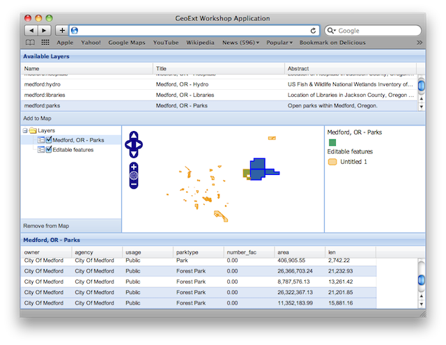
A synchronized map and grid view of WFS features.
3.1.1.1. Understanding the Code
As we already know, we can configure a grid with a store to tell it where to get its data from. This time we use a GeoExt.data.FeatureStore that we configure with a GeoExt.data.ProtocolProxy to access an OpenLayers.Protocol.WFS.
The synchronization of selections in the grid and on the map is provided by the GeoExt.grid.FeatureSelectionModel, which we use instead of the default selection model:
sm: new GeoExt.grid.FeatureSelectionModel(),
When we add the vector layer to the map, we also have to bind the selection model and the store to it:
app.featureGrid.store.bind(vectorLayer);
app.featureGrid.getSelectionModel().bind(vectorLayer);
Note that this is not necessary if the FeatureStore is configured with a
layer. But since we create the store before the layer here, we don’t have
access to it yet, so we bind it later.
Bonus Task
Warning
Dragons ahead! Understanding the code from this exercise will be hard for readers without solid programming background. Please skip this task unless
- you are really, really willing to learn and spend an hour on this,
- not understanding code that you paste does not make you unhappy.
The need to manually configure a WFS layer with all the fields and columns makes the application less convenient than we want it to be. Ideally, we could select a layer in the tree, and the grid would automatically display its feature attributes, and the features could be selected in the grid and the map.
Many WMS/WFS implementations, like GeoServer in our case, use the same layer (feature type) names for WMS and WFS. For other WMS implementations, there is a DescribeLayer request which returns an XML document that gives us the link from the WMS layer to an associated WFS feature type or WCS coverage. Once we know the WFS feature type name, we can issue a WFS DescribeFeatureType request to get the fields and data types for the feature attributes. The disadvantage of omitting the DescribeLayer request is that the DescribeFeatureType request will fail for raster layers. This is not a big deal though - in our implementation it only means that the grid and layer will be cleared when we select a raster layer.
For this bonus exercise, we assume that the WMS layer name is the same as the WFS FeatureType name, so we don’t issue a WMS DescribeLayer request. But we do issue a WFS DescribeFeatureType to auto-configure the feature records and the grid.
GeoExt has an AttributeStore which holds the field metadata of the feature attributes. It uses OpenLayers.Format.WFSDescribeFeatureType to obtain this information, but discards anything but the field data. For accessing the WFS layer, we also need the feature namespace, so we intercept the read method to obtain all of the DescribeFeatureType response’s raw data. Let’s add the following at the end of our script block:
var rawAttributeData;
var read = OpenLayers.Format.WFSDescribeFeatureType.prototype.read;
OpenLayers.Format.WFSDescribeFeatureType.prototype.read = function() {
    rawAttributeData = read.apply(this, arguments);
    return rawAttributeData;
};
The FeatureStore and the grid need to be reconfigured when we select a different layer in the tree. Append the following function to the application code:
function reconfigure(store, url) {
    var fields = [], columns = [], geometryName, geometryType;
    // regular expression to detect the geometry column
    var geomRegex = /gml:(Multi)?(Point|Line|Polygon|Surface|Geometry).*/;
    var types = {
        // mapping of xml schema data types to Ext JS data types
        "xsd:int": "int",
        "xsd:short": "int",
        "xsd:long": "int",
        "xsd:string": "string",
        "xsd:dateTime": "string",
        "xsd:double": "float",
        "xsd:decimal": "float",
        // mapping of geometry types
        "Line": "Path",
        "Surface": "Polygon"
    };
    store.each(function(rec) {
        var type = rec.get("type");
        var name = rec.get("name");
        var match = geomRegex.exec(type);
        if (match) {
            // we found the geometry column
            geometryName = name;
        } else {
            // we have an attribute column
            fields.push({
                name: name,
                type: types[type]
            });
            columns.push({
                xtype: types[type] == "string" ?
                    "gridcolumn" :
                    "numbercolumn",
                dataIndex: name,
                header: name
            });
        }
    });
    app.featureGrid.reconfigure(new GeoExt.data.FeatureStore({
        autoLoad: true,
        proxy: new GeoExt.data.ProtocolProxy({
            protocol: new OpenLayers.Protocol.WFS({
                url: url,
                version: "1.1.0",
                featureType: rawAttributeData.featureTypes[0].typeName,
                featureNS: rawAttributeData.targetNamespace,
                srsName: "EPSG:4326",
                geometryName: geometryName,
                maxFeatures: 250
            })
        }),
        fields: fields
    }), new Ext.grid.ColumnModel(columns));
    app.featureGrid.store.bind(vectorLayer);
    app.featureGrid.getSelectionModel().bind(vectorLayer);
}
Note that the way we build the
fieldsandcolumnsarrays results in exactly the same configuration for the medford:parks layer that we manually wrote in the previous exercise.When a layer is selected in the tree by clicking on its name, we want to issue a DescribeFeatureType request. This is done by appending the following code:
function setLayer(model, node) {
    if(!node || node.layer instanceof OpenLayers.Layer.Vector) {
        return;
    }
    vectorLayer.removeAllFeatures();
    app.featureGrid.reconfigure(
        new Ext.data.Store(),
        new Ext.grid.ColumnModel([])
    );
    var layer = node.layer;
    var url = layer.url.split("?")[0]; // the base url without params
    var schema = new GeoExt.data.AttributeStore({
        url: url,
        // request specific params
        baseParams: {
            "SERVICE": "WFS",
            "REQUEST": "DescribeFeatureType",
            "VERSION": "1.1.0",
            "TYPENAME": layer.params.LAYERS
        },
        autoLoad: true,
        listeners: {
            "load": function(store) {
                app.featureGrid.setTitle(layer.name);
                reconfigure(store, url);
            }
        }
    });
}

Ext.onReady(function() {
    app.tree.getSelectionModel().on(
        "selectionchange", setLayer
    );
});
Note that this code calls the
reconfigurefunction in the store’s load handler. So when the user selects a layer in the tree,setLayeris called asselectionchangehandler on the tree’s selection model, and the DescribeFeatureType request for the selected layer is issued. Once the response is available,reconfigureis called.After saving your changes, point your browser to http://localhost:8080/ol_workshop/map.html. When you have added a layer to the map that is available as WFS also and select it in the tree, the grid will be populated with the layer’s feature attributes, and the features will be rendered on the map.
3.1.2. Next Steps
Just displaying vector features is somewhat boring. We want to edit them. The next section explains how to do that.