2.2. Adding a Tree View to Manage the Map Panel’s Layers
With the Ext.tree.TreePanel and its tree nodes, Ext JS provides a powerful tool to work with hierarchical information. While Ext JS trees cannot be populated from stores, GeoExt provides a tree loader that can turn information from a layer store into tree nodes. Configured with checkboxes, these can be used to turn layers on and off. In addition, thanks to drag & drop support of Ext JS trees, layers can easily be reordered.
2.2.1. Using a Tree Panel for Layer Management
Let’s add a tree to the example from the previous section. To do so, we create a tree panel with a GeoExt.tree.LayerContainer, and add it as new item to our application’s main panel.
Tasks
If you don’t have it open already, open
map.htmlfrom the previous example in a text editor. Add the following tree definition at the end of our application’s script block:items.push({ xtype: "treepanel", ref: "tree", region: "west", width: 200, autoScroll: true, enableDD: true, root: new GeoExt.tree.LayerContainer({ expanded: true }), bbar: [{ text: "Remove from Map", handler: function() { var node = app.tree.getSelectionModel().getSelectedNode(); if (node && node.layer instanceof OpenLayers.Layer.WMS) { app.mapPanel.map.removeLayer(node.layer); } } }] });
Reload http://localhost:8080/ol_workshop/map.html in your browser to see the changes. On the left-hand side of the map, we have a tree now. Add some layers from the grid to the map and watch them also appear in the tree. Use the checkboxes to turn layers on and off. Drag and drop layers in the tree to change their order on the map. Select a layer by clicking on the node text, and remove it by clicking the “Remove from Map” button.
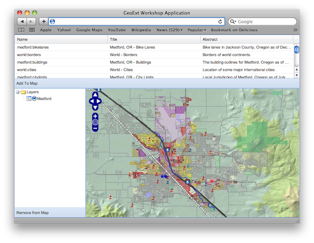
A tree view of the map’s layers for convenient layer management
2.2.1.1. Looking at the New Code More Closely
First, let’s have a look at the tree configuration again to see what it consists of.
As we already saw, we can drag and drop tree nodes. This is enabled by
setting enableDD: true. More interesting is the root property.
root: new GeoExt.tree.LayerContainer({
    expanded: true
}),
Every tree needs to have a root node. GeoExt provides a special layer
container node type. Configured with the map panel’s layer store as its
layerStore config option, it will be populated with layer nodes for each of
the map’s layers. Note that we omitted the layerStore config option. The
LayerContainer takes the layers property from the first MapPanel it finds
in the Ext JS registry in this case.
The nodes the LayerContainer is populated with are GeoExt.tree.LayerNode instances. The container makes sure that the list of layers is always synchronized with the map, and the node’s checkbox controls the layer’s visibility.
Surprisingly, adding a root node that has all map layers as children requires less coding effort than the button to remove layers:
bbar: [{
    text: "Remove from Map",
    handler: function() {
        var node = app.tree.getSelectionModel().getSelectedNode();
        if (node && node.layer instanceof OpenLayers.Layer.WMS) {
            app.mapPanel.map.removeLayer(node.layer);
        }
    }
}]
We already know the concept of a bottom toolbar from a previous exercise. The flesh of the above snippet is the handler
function that gets executed when the button is clicked. Like the grid, the
tree also has a selection model. The default selection model only supports
selection of one node at a time, and we can get the selected node using its
getSelectedNode() method. All that is left to do is check if there is a
selected node, and if the layer is a WMS layer (we don’t want to allow removal
of vector or other layers we might be adding manually), and remove the layer
from the map using the removeLayer() method of the OpenLayers.Map
object.