1.1. Creating a Map Window
In GeoExt, following the conventions of the underlying Ext JS framework, a map is wrapped into an Ext.Panel. The map is an OpenLayers.Map object.
It is important to understand that Ext JS encourages a web application paradigm, as opposed to a web page paradigm. This means that we won’t create markup, so the basic ingredients of our application will be:
- a minimal html document to include JavaScript and CSS resources,
- JavaScript code for application initialization,
- JavaScript code that builds the user interface,
- “Glue” JavaScript code that makes the pieces work together. We don’t have any in this basic example, so we will be learning about it later.
1.1.1. Working Example
Let’s take a look at a fully working example of a simple GeoExt application:
<html>
    <head>
        <title>GeoExt Workshop Application</title>
        <link rel="stylesheet" type="text/css" href="ext/resources/css/ext-all.css">
        <script type="text/javascript" src="ext/adapter/ext/ext-base.js"></script>
        <script type="text/javascript" src="ext/ext-all.js"></script>
        <script src="openlayers/lib/OpenLayers.js"></script>
        <script type="text/javascript" src="geoext/lib/GeoExt.js"></script>

        <script type="text/javascript">

        Ext.BLANK_IMAGE_URL = "ext/resources/images/default/s.gif";
        var app, items = [], controls = [];

        Ext.onReady(function() {
            app = new Ext.Viewport({
                layout: "border",
                items: items
            });
        });

        items.push({
            xtype: "gx_mappanel",
            ref: "mapPanel",
            region: "center",
            map: {
                numZoomLevels: 19,
                controls: controls
            },
            extent: OpenLayers.Bounds.fromArray([
                -122.911, 42.291,
                -122.787,42.398
            ]),
            layers: [new OpenLayers.Layer.WMS(
                "Medford",
                "/geoserver/wms",
                {layers: "medford"},
                {isBaseLayer: false}
            )]
        });
        controls.push(
            new OpenLayers.Control.Navigation(),
            new OpenLayers.Control.Attribution(),
            new OpenLayers.Control.PanPanel(),
            new OpenLayers.Control.ZoomPanel()
        );

        </script>
    </head>
    <body>
    </body>
</html>
Tasks
- Copy the text above into a new file called
map.html, and save it in the root of the workshop folder. - Open the working application in your web browser: http://localhost:8080/ol_workshop/map.html
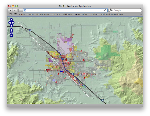
A working map displaying the town of Medford.
Having successfully created our first GeoExt application, we’ll continue by looking more closely at the parts.
Previous: 1. GeoExt Basics